Better Transport Outcomes for Merri-bek and the Upfield Corridor
Transport investments must maximise accessibility, reliability, and value for taxpayers while respecting local communities and active transport users.
Responsible Infrastructure Investment
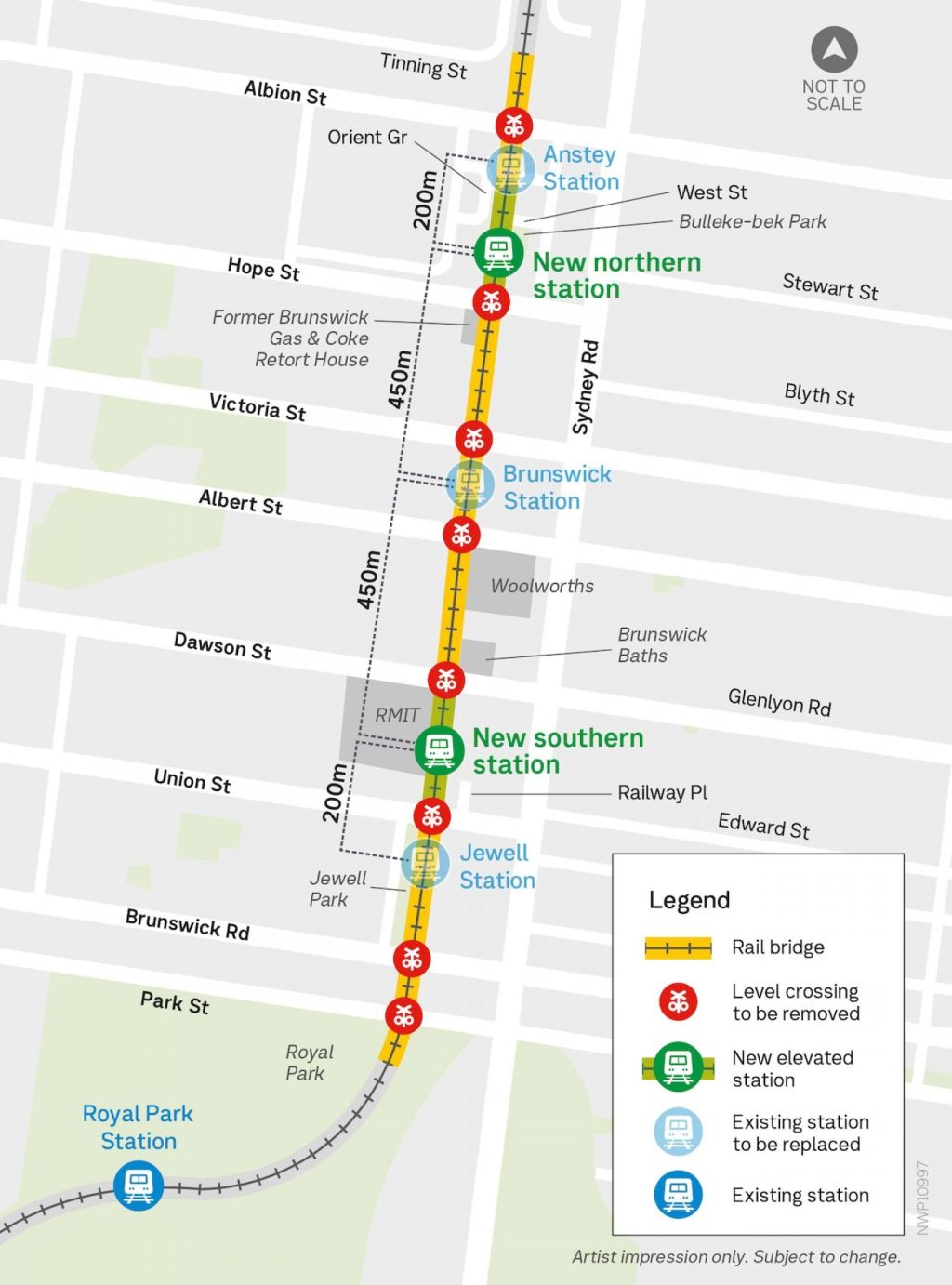
With the Brunswick Level Crossing Removal Project projected to cost well over $1 billion, I believe major infrastructure projects must demonstrate clear public benefit and value for money. At a time when Victoria’s net debt is forecast to exceed $187 billion, all transport spending must be assessed against competing priorities, including regional rail upgrades, track duplications, and rapid bus networks that may deliver greater benefits across the state.
Accessible Public Transport First
Accessibility upgrade of Sydney Road tram stops must happen before any major disruption to the Upfield rail corridor occurs. During extended rail and shared-path closures, residents, particularly people with disabilities, older Victorians, and those with mobility needs, must have access to reliable and accessible alternative transport options.
Better East-West Connectivity
While Merri-bek is well served by north-south train and tram routes, east-west public transport remains limited. I:
- Support increased frequency and reliability of east-west bus services.
- Advocate for expanded evening and weekend bus operations, including improved Sunday services.
- Prioritise bus network upgrades in areas experiencing chronic congestion and poor transport access.
Fixing the Upfield Line Bottleneck
The single-track section between Gowrie and Upfield stations remains one of the corridor’s biggest operational constraints. I advocate for investment to remove this bottleneck, improving reliability, reducing delays, and supporting future service increases across the Upfield line.
A Safe and Continuous Cycling Network
The Upfield Shared User Path is one of Melbourne’s most heavily used cycling corridors. I:
- Support the removal of unsafe crossings and path discontinuities.
- Advocate for high-quality active transport connections during construction.
- Prioritise pedestrian and cycling access in any project design decisions.
Putting Active Transport at the Centre of Design
Infrastructure solutions must not create unnecessary barriers for people walking and cycling. In locations such as Park Street, project designs should minimise steep gradients and prioritise safe, continuous active transport links rather than focusing solely on vehicle clearance requirements.
Protecting Local Accessibility
I support retaining convenient access to public transport for Brunswick residents. Any station consolidation proposals must be assessed against their impact on walking distances, accessibility, and community access, particularly for:
- People with disabilities.
- Elderly residents.
- Students and other public transport-dependent groups.
Transport projects should not come at the expense of local accessibility. I advocate for solutions that improve network performance while preserving convenient access to public transport throughout Merri-bek.
My vision is simple: a transport network that is accessible, reliable, financially responsible, and designed around the needs of local communities rather than engineering convenience alone.
Google backgrounder
A Cost-Benefit Analysis (CBA) for the Brunswick Level Crossing Removal Project (Skyrail) reveals a highly complex infrastructure equation. The project involves elevating a 2.1-kilometre section of the Upfield train line between Park Street (Parkville) and Albion Street (Brunswick) to remove eight dangerous, congested level crossings. [1, 2, 3]
Formally deferred in state budgets due to severe fiscal constraints, the project is tracking toward a 2030 completion date. Estimated to cost well in excess of $1 billion, the structural economic return must be viewed from both macro-level transport data and localized neighborhood dynamics. [2, 3, 4]
📈 1. Economic & Transport Benefits (The Monetised Returns)
The Level Crossing Removal Project (LXRP) Program Business Case models macro economic value across several primary travel indicators: [5]
Road Congestion & Travel Time Savings
- The Return: Eliminates half an hour of boom gate downtime during the morning peak alone.
- The Valuation: This systematically slashes travel delays for an estimated 71,000 weekday drivers, directly capturing value by lowering vehicle idling emissions, commercial delivery delays, and private commuting times. [5, 6, 7]
Active Transport & Urban Open Space Realignment
- The Return: Elevating the tracks unlocks two MCGs worth of new community open space directly underneath the concrete spans.
- The Valuation: The project funds the separation of pedestrian walking paths from the high-volume Upfield Shared User Path (Upfield Bike Path). This reduces pedestrian-cyclist collisions and supports sustainable transport, which helps reverse local economic losses (“escape expenditure”) by boosting streetscape amenity near the Sydney Road shopping precinct. [2, 5, 8, 9, 10, 11]
Network Reliability & Future Upgrades
- The Return: Removes critical bottlenecks that cause cascading delays across the metropolitan rail grid.
- The Valuation: Removing the boom gates paves the way to run more trains on the Upfield line. It resolves a major constraint on line duplication north of Gowrie, which is a $246 million project being actively pushed by infrastructure lobbies to drop peak wait times from 20 minutes down to 10 minutes. [4, 7, 9, 10, 12]
📉 2. Project Costs & Macro Negative Drag [13]
Extreme Capital Outlays
- The Drag: Stripping out eight inner-city level crossings within a narrow, heavily built-up urban corridor carries extreme technical costs. [2, 3]
- The Valuation: With a price tag well exceeding $1 billion, the project capital cost significantly impacts Victoria’s current net debt, which is legally projected to pass $187 billion. The opportunity cost is high; critics note that the same capital could fund multiple regional track duplications or rapid bus networks elsewhere. [3]
Structural Business & Social Disruptions
- The Drag: Constructing high-span elevated rail structures requires years of rolling detours, dust pollution, noise impacts, and heavy freight truck diversions. [14]
- The Valuation: Temporary closures of the Upfield line and the shared path displace thousands of commuters onto an already congested Sydney Road corridor. Businesses lose foot traffic, and parts of local reserves (such as Clifton Park and Bulleke-bek Park) face rolling temporary closures for machinery storage, reducing neighborhood amenity during the multi-year build. [2, 14]
⚖️ 3. The Net Benefit-Cost Ratio (BCR) Stalemate
The Victorian Government standardly calculates infrastructure returns using a 7% real discount rate, but presents sensitivity analysis matching global infrastructure guidelines at a 4% real discount rate. According to the audited LXRP Program Business Case, the economic metrics perform as follows: [5]
- At a 7% Discount Rate (Standard Transport Metric): The standalone LXRP program yields a BCR of 0.78. This indicates that for every dollar of taxpayer capital spent, the monetized transport benefits return roughly 78 cents—representing a net economic deficit when isolated from wider land-use gains. [5]
- At a 4% Discount Rate (Social Value Metric): When calculating the wider, long-term value of urban tree canopies, permanent neighborhood safety upgrades, and bike path additions, the BCR rises to 1.34. This clears the threshold for public value creation, helping justify the project’s return to the construction pipeline. [5, 7, 9, 11]
📊 Brunswick Skyrail Cost-Benefit Blueprint
| Monetised Benefit Streams (The Upside) [2, 3, 4, 5, 6, 8, 9, 10, 14, 15] | Structural Cost Pressures (The Downside) |
|---|---|
| Eliminating 30 mins peak boom gate downtime | Direct CAPEX exceeding $1 Billion in public funds |
| Gaining 2 MCGs of public urban open space | Multi-year disruption to the Sydney Road traffic flow |
| Separated walking/cycling loops on the Upfield Path | Temporary closures and workspace leaks into local parks |
| Paves the way for future line duplication & higher frequency | Accelerated interest payments adding to Victoria’s state debt |
| Appraisal Output (Standard): 0.78 BCR (Net economic loss) | Appraisal Output (Social): 1.34 BCR (Net public gain) |
[2] https://www.merri-bek.vic.gov.au
[3] https://brunswickvoice.com.au
[4] https://brunswickvoice.com.au
[5] https://bigbuild.vic.gov.au
[8] https://bigbuild.vic.gov.au
[9] https://bigbuild.vic.gov.au
[10] https://bigbuild.vic.gov.au
[11] https://conversations.merri-bek.vic.gov.au
[13] https://brunswickvoice.com.au
[14] https://engage.vic.gov.au
[15] https://www.dailymotion.com
For the 2,500 daily active transport commuters navigating inner-Melbourne, the Brunswick Skyrail project presents a sharp operational trade-off: a highly disruptive, multi-year construction bottleneck followed by a “world-class” infrastructure upgrade. [1]
The real on-ground impacts for cyclists and pedestrians break down into two distinct phases.
🛑 Phase 1: The Construction Phase (The Disruptions)
The 18-Month Upfield Path Closure [2]
- The Impact: To safely build the 2.1-kilometre elevated concrete rail bridge, the Upfield Shared User Path (Upfield Bike Path) will face a total closure for up to 18 months. [2, 3]
- The Reality: Around 1,500 core daily bike commuters will be forced off this dedicated off-road highway. Advocates from the Bicycle Network warn that the proposed on-road detours are highly fragmented. They require less confident riders to cross major arterial roads without traffic lights, ride on narrow pedestrian footpaths, and navigate steep topographic climbs, which may drive many back into private cars. [2]
The Sydney Road Traffic Squeeze [4]
- The Impact: The path closure directly collides with an already congested Sydney Road corridor.
- The Reality: Despite heavy local lobbying from Climate Action Merri-bek and community groups for a temporary, protected bike lane down Sydney Road during construction, the current state planning framework maintains the existing on-road configuration. Cyclists using Sydney Road will face intense conflict with diverted delivery vans, trams, and vehicles trying to bypass the closed level crossing side-streets. [2, 5]
Local Park & Open Space Encroachment
- The Impact: Constructing massive overhead concrete spans requires extensive ground-level laydown yards for cranes, structural pillars, and soil stockpiles.
- The Reality: High-amenity neighborhood parks—such as Clifton Park and Bulleke-bek Park—face rolling, temporary closures of their walking tracks and green open spaces, reducing local pedestrian recreation areas during the build.
🟢 Phase 2: The Completion Phase (The Upgrades)
Once the project is delivered, the active transport landscape will permanently change for the better.
Complete Separation of Conflict Zones
- The Impact: The current Upfield Path is a highly congested “Shared User Path” where fast-moving commuter cyclists frequently collide with pedestrians, dogs, and pram-pushers. [2, 6]
- The Reality: The new design transforms the path, delivering fully separated walking and cycling paths running from Moreland Road to Park Street (Parkville). This matches the high-quality design already functioning successfully further north through Coburg. [1, 3, 7]
Dismantling the East-West Neighborhood Barrier [7]
- The Impact: Historically, the ground-level train tracks and closed boom gates function as a physical wall, severing Brunswick’s east from its west. [7, 8]
- The Reality: Elevating the line unlocks 2 MCGs worth of new community open space directly beneath the tracks. Pedestrians will gain new, step-free east-west walking links every few hundred meters, connecting residential zones directly to RMIT University and the Sydney Road shopping precinct without waiting at tracks. [7, 8, 9]
Enhanced Safety & Lighting Metrics
- The Impact: Portions of the legacy trail are narrow, poorly lit, and suffer from blind corners.
- The Reality: Built to Crime Prevention Through Environmental Design (CPTED) principles, the upgraded path through the station hubs will integrate high-lux LED public lighting, open line-of-sight landscaping, and advanced CCTV surveillance networks to improve safety for night-time commuters. [7]
📊 Active Transport Impact Ledger
The immediate negative changes versus the long-term structural returns are summarized below:
| Construction Phase Pressures (The Friction) [2, 5, 7, 8, 10] | Post-Completion Assets (The Outcome) |
|---|---|
| Total 18-month closure of the vital Upfield Bike Path | 4km of continuous, separated walking & cycling tracks |
| Dangerous on-road detours without protected lanes | Elimination of all pedestrian boom-gate wait times |
| Temporary loss of walking tracks inside Clifton Park | 2 MCGs of newly created, land-scaped public open space |
| Increased bike-car conflict zones along Sydney Road | CPTED-compliant public lighting, clear sightlines & CCTV |
[1] https://bigbuild.vic.gov.au
[3] https://bicyclenetwork.com.au
[5] https://www.merri-bek.vic.gov.au
[6] https://climateactionmerribek.org
[7] https://bigbuild.vic.gov.au
[8] https://bigbuild.vic.gov.au
[9] https://bigbuild.vic.gov.au
[10] https://bigbuild.vic.gov.au
[11] https://conversations.merri-bek.vic.gov.au
The conflicts between local transport planning by the Merri-bek City Council and state transport planning by the Level Crossing Removal Project (LXRP) regarding the Brunswick Skyrail project center on balancing state-wide rail efficiency against localized urban amenity, business health, and accessibility. [1, 2, 3, 4, 5]
While both tiers of government agree on removing the eight dangerous level crossings between Park Street and Albion Street, major friction points have emerged across several key planning domains: [6, 7]
1. The Consolidation of Railway Stations
- State Objective: The Victorian Government decided to replace the three existing heritage stations (Jewell, Brunswick, and Anstey) with just two new stations. The state’s engineering and technical assessments concluded that fewer stations would improve overall network capacity, decrease train travel times, and maximize new open park space underneath the tracks. [3, 8]
- Local Friction: Merri-bek Council and local lobby groups like the Brunswick Residents Network aggressively advocated for retaining all three stations. Local planners argue that removing a station increases walking distances and decreases transit accessibility, particularly affecting the area’s dense pocket of disabled, elderly, and student residents. [8, 9, 10, 11]
2. The Sydney Road Tram Accessibility Bottleneck
- Local Friction: The council’s strategic document, Reshaping Brunswick, demands that the state’s Department of Transport and Planning upgrade Sydney Road’s tram stops to be fully accessible before the rail line is disrupted. During construction, the Upfield train line and its parallel shared bike path face total closures for months at a time. Without level-access tram stops on Sydney Road, commuter overflow will have no wheelchair-accessible alternative transport. [4, 8, 9, 11, 12, 13]
- State Objective: The state government has refused to commit to transforming Sydney Road concurrently with the Skyrail project. Upgrading tram stops requires removing large amounts of on-street parking, creating a separate local political conflict with retail traders that the state has chosen not to absorb into the rail project’s scope. [11, 14]
3. Active Transport vs. Traffic Engineering (Park Street)
- State Objective: To keep the elevated rail from descending too late, the state plans to dramatically lower the road level at Park Street to ensure sufficient 4.8-metre bridge clearance for vehicles without creating a low-clearance hazard.
- Local Friction: Local walking and cycling advocates point out that lowering the road surface forces the north-south Upfield Shared User Path to experience steep grade changes. Local planning places pedestrians and cyclists at the top of the transport hierarchy, while the state’s solution prioritizes maintaining standard road vehicle clearance over flat, seamless active transit routes. [10, 12, 15, 16]
4. Construction Timelines and Economic Disruption
- State Objective: Due to shifting state budget priorities and escalating debt, the Victorian Government delayed major construction, pushing the project’s completion timeline from 2027 back to 2030.
- Local Friction: The council expressed frustration that the three-year delay prolongs economic uncertainty for hundreds of small businesses. Local traders operating along the narrow Upfield corridor face immense anxiety over a projected loss of patronage and pedestrian access, forcing the council to construct its own separate Urban Design Framework to try to shield local business hubs from state-managed disruptions. [5, 7, 14, 17, 18, 19]
Current transport campaigns in the City of Merri-bek and the state electorate of Brunswick focus on fixing accessibility gaps, upgrading local bus networks, ensuring active transport safety, and reacting to state-led infrastructure changes. [1, 2]
With local community groups, the Greens-held state seat, and the Merri-bek Council aligned on several key fronts, advocacy has intensified around several core campaigns: [1, 3]
1. The Sydney Road Accessible Tram Stop Campaign
- The Issue: The Route 19 tram running down Sydney Road remains largely inaccessible to wheelchair users, parents with prams, and less-mobile residents due to a distinct lack of level-access, raised tram platforms. [4, 5, 6, 7]
- The Campaign: Led by grass-roots groups like the Brunswick Residents Network (BRN), local councilors (including Cr Sue Bolton), and Brunswick MP Tim Read, advocates are demanding immediate action. Following a highly visible protest march up Sydney Road, the movement secured $200,000 in council budget funding over two years for a corridor study to force the State Government to invest in permanent, accessible infrastructure. [1, 4, 8, 9, 10]
2. East-West Bus Frequency Upgrades
- The Issue: While north-south train and tram lines are frequent, east-west movement across Merri-bek relies on infrequent, heavily congested bus lines that often finish running early or lack Sunday services. [11, 12, 13]
- The Campaign: Organized by Climate Action Merri-bek (CAM) and Melbourne on Transit, community pressure scored partial funding in the state budget for frequency boosts on the 508 (Moonee Ponds to Alphington) and 526 routes. Current ongoing campaigns are pushing for Sunday services on the 503 and 506 routes in Brunswick, alongside a newly launched parliamentary petition targeting bus service improvements in Merri-bek’s northern corridors (like the 534 route). [10, 11, 14]
3. Upfield Rail Line Duplication and Extension
- The Issue: The Upfield line suffers from a major single-track bottleneck between Gowrie and Upfield stations, meaning delays trigger domino-effect cancellations across the entire corridor.
- The Campaign: As highlighted in Merri-bek Council’s State Election Advocacy Priorities, the council is aggressively campaigning for the state to duplicate the remaining single track, extend the line to Craigieburn, and electrify the network all the way to Wallan. This is paired with campaigns to push the Level Crossing Removal Project (LXRP) for better urban design outcomes during the Brunswick Skyrail delay. [1, 15, 16, 17, 18]
4. Active Transport & Street Safety (The Hope Street Project)
- The Issue: Local east-west streets like Hope Street in Brunswick are suffering from heavy vehicle traffic (4,500+ vehicles daily) and speeding, acting as “rat runs” between major arteries.
- The Campaign: Residents and walking/cycling groups are actively campaigning around Merri-bek’s draft concept plans to close the Hope Street railway crossing to motor vehicles entirely. The broader campaign pushes for separated, protected cycling lanes, a $100,000 rollout of “wombat” pedestrian crossings on Albion Street West, and a push to lower speed limits in high-density pockets to 30 km/h. [8, 19, 20, 21, 22]
5. Fixing the Upfield Shared User Path Missing Links
- The Issue: The Upfield bike and pedestrian path is one of Melbourne’s busiest bicycle highways but features jarring disconnects and unsafe crossings.
- The Campaign: Transport planners and bicycle lobbies are running a targeted campaign to fund and plan the path’s missing link from Sages Road to the M80 Trail, demanding a signalised pedestrian crossing at Box Forest Road to protect the path’s 2,500 daily users. [23]


Leave a Reply